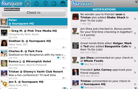
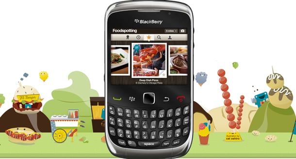
Cell Phone News

LBS News
Subscribe to the LBS RSS Feed

DUBMeNow Updated With Location-Based Connections

By Simon Sage on Thursday, August 27th, 2009 at 7:37 AM PST
In Applications, BlackBerry, LBS, Productivity, Social Networking, iPhone

 DUBMeNow Updated With Location Based ConnectionsDUBMeNow is a snazzy little application for BlackBerry (NSDQ: RIMM), iPhone and Android that came out awhile ago whose key feature was to automatically update your native address book whenever information changes – phone, e-mail, address, you name it. The catch, of course, was that both people needed to be registered users in order for the exchange to happen. An update released today includes GPS integration as well as a whole batch of social network support that may very well help convince the skeptical to install the mobile app. A new “locate” feature finds where you and your potential business card swap-ee are situated, and automatically prompts both to make the switch. You can also tweet who you’re meeting, send LinkedIn requests, and keep tabs on their Facebook account. While I still find the process a little more convoluted than, say, contxts, or even QR codes, but I’ll probably keep the new DUBMeNow app arhived on my Bold on the off-chance that folks I meet at trade shows are already signed up. If you happen to shake a lot of hands in your line of business, check it out in the BlackBerry App World, iPhone App Store, or Android Market.

Augmented Reality Android Traffic App Looks Down the Road

By Simon Sage on Wednesday, August 26th, 2009 at 7:29 AM PST
In Android, Augmented Reality, LBS, Travel

This is pretty cool. Some basement developer in Toronto has cooked up an Android app that figures out which geocoded traffic cameras are on your estimated route, allowing you to check out conditions down the road before you get stuck in a jam. Trust me, having gone down the 401 a few times myself, it’s not somewhere you want to be around during rush hour. For a wider view, you can also look at traffic conditions in map mode. I’m still not sold on the interface in the proper augmented reality portion of the app, which overlays a list of bullets of the traffic cameras in the direction you’re pointing the phone, but it’s nothing a few good coats of paint can’t fix. Proximity alerts for speed traps and user-defined points of interest are also snazzy features, and make this a really well-rounded driving companion app. It looks like they’re working on some real estate points of interest for the future, too. If you’re in the Toronto area and packing a Magic or Dream, check out Augmented Traffic Views in the Android Market. Best of all, it’s free!

[via Wired]

Twitter to Add Location API

By Simon Sage on Friday, August 21st, 2009 at 7:18 AM PST
In Developer, GPS/Satellite Navigation, LBS, Social Networking

MapPins Twitter to Add Location APITwitter, the long-standing mobile social network of choice, will soon be able to pull your GPS coordinates if you’re tweeting from a supported device and opt in for the service. This means individual tweets will be geolocated, allowing you to easily see who’s tweeting what around you. There are already a few augmented reality apps that are trying to tap into that demand, but with an official API soon available for developer preview, those apps will likely see a significant boost in readable tweets.

Now, if these APIs plugged into something like Fire Eagle, you would be able to update a number of location-based services whenever you tweet, but exact details are a little skimpy right now. Biz Stone makes a point to say “the exact location data won’t be stored for an extended period of time”, which seems like a shame to me. For example, it would be really nice to share your geotagged tweets from a road trip, and show what you had to say about where you stopped and what you were doing. The idea that the coordinates would just evaporate after a couple of months is pretty lame, although we might put some emphasis on the word “exact”, and presume they still keep location data for, say, the city-level. Exciting news, in any case – we’ll be watching intently for when the feature goes live.

[via Twitter Blog]

Urban Kite now Available on Android

By Simon Sage on Wednesday, August 12th, 2009 at 2:03 PM PST
In Android, Applications, LBS, Social Networking

android urbankite Urban Kite now Available on AndroidAnother cool app for Android out today is Urban Kite, an app which lets you add comments to particular points of interest in your area. The nice thing about Urban Kite is that its points of interest are populated by Google (NSDQ: GOOG) Local and the comments are made through Twitter and bit.ly. Being able to share your thoughts on a particular restaurant without worrying that they’ll just be sent to a sheltered community that is used only by those who install the app can be a deterrent for these kind of services, but if your comments are going out to Twitter and Google as well, it’s easy to see Urban Kite getting popular. A feature coming soon sounds pretty interesting: “Discover like-minded local experts in your area via the places you have in common and find out what else they do for kicks in the neighbourhood”. A bit of a match-making service, no? Check it out on the Android Market, or swing by their site for more info. Can we get a BlackBerry (NSDQ: RIMM) version soon?

OpenTable offers Dinner Reservations on BlackBerry

By Simon Sage on Tuesday, August 4th, 2009 at 11:35 AM PST
In Applications, BlackBerry, LBS

blackberry opentable OpenTable offers Dinner Reservations on BlackBerryThe Palm (NSDQ: PALM) Pre wasn’t the only handset to get support for OpenTable lately – a BlackBerry (NSDQ: RIMM) version of their app is also now available. A quick search will not only help you find restaurants in your neighbourhood (organized by cuisine category, if you’re feeling picky) and allow you to reserve a table right from your mobile. Viigo had offered some of OpenTable’s service not long ago,  but a dedicated app will be a good choice for those who eat out often. Check out OpenTable’s standard website to see what’s available in your area, and if you’re happy with the selection, download the app for free from App World. Oh, and OpenTable is also available for iPhone, if you’re into that kind of thing.

Google Latitude Coming to iPhone Today

By Simon Sage on Thursday, July 23rd, 2009 at 12:56 PM PST
In Applications, LBS, Social Networking, iPhone

Details are slim, but word has it that Google (NSDQ: GOOG)’s location-sharing service built into Maps for Mobile will be hitting iPhone before the end of the day. The announcement that Latitude would be making the jump was made by Google VP of Mobile Vic Gundotra at the Fortune Brainstorm Tech conference not long ago. We had seen Latitude working in the mobile Safari browser in a demo before, Fire up your App Stores, iPhone users, and get ready to catch up to Android and BlackBerry (NSDQ: RIMM). Jussayin’.

[via Fortune]

UPDATE: So, apparently it’s not a separate app, they’re actually using the Safari-based Latitude model – hit up m.google.com/latitude to update your location. I dunno, doesn’t that seem a little… unwieldly?

Acrossair Helps Find Your New York Subway Station

By Simon Sage on Friday, July 17th, 2009 at 12:07 PM PST
In Applications, Augmented Reality, LBS, Travel, iPhone

Acrossair is showing off a great new location-based augmented reality app for the iPhone that helps New Yorkers work their way around the subway. As you can see from the video, it makes good use of direction detection the iPhone 3GS by showing you both which stations are in the way you’re facing the camera, as well as how far away they are. If they can include all of the functionality of Google (NSDQ: GOOG) Maps for Mobile’s transit directions, then I think we’ve got a winner for the new public transportation app of choice. Acrossair has already earned an award for their London tube version of this app, and testing is underway for San Francisco, Chicago, Washington D.C., Tokyo, Berlin, and Barcelona, even though the software is still awaiting App Store approval. With any love, we’ll see versions popping up for even more metropolitan areas in the future.

I’m curious how it works underground in systems that don’t have data coverage – Barcelona won’t be a problem, but New York is still testing the waters. To keep up to date on the progress of the New York Nearest Subway app, be sure to check out Acrossair’s site.

Google Search on iPhone 3.0 Locates Position

By Simon Sage on Thursday, July 16th, 2009 at 2:59 PM PST
In LBS, Mobile Web, iPhone

iphone googlelbs Google Search on iPhone 3.0 Locates PositionGoogle has updated their mobile search page for those visiting through Safari on iPhones running OS 3.0. Now your search will take into account My Location, to provide location-contextualized results. The feature has been included in the iPhone Google (NSDQ: GOOG) Mobile App for a long time already, but this is a cool addition for those who haven’t bothered to install it (who knows why anyone wouldn’t, though). I’m curious if the function extends to searches initiated through the search field in Safari’s address bar, though…

[via Official Google Mobile Blog]

LiveJournal Now Location-Aware on Windows Mobile

By Simon Sage on Thursday, July 16th, 2009 at 2:40 PM PST
In LBS, Social Networking, Windows Mobile

windowsmobile lj 300x95 LiveJournal Now Location Aware on Windows Mobile

Hey wow, LiveJournal’s still around. Whodathunkit? Not only that, but they’ve announced that anyone blogging on their service through a Google (NSDQ: GOOG) Gears-enabled Windows Mobile device can now geotag their posts. All you have to do is hit the Detect button in the Location field, and it’ll figure out where you are. Even without Google Gears, the detect button will work on desktop using your IP address, which can drill down to the city without any problems. Cool stuff overall – now to go over my old LJ blog, where the magic started.

[LiveJournal via wmpoweruser]

Shazam Plays Nice with Twitter and, For Some Reason, Google Maps

By Simon Sage on Wednesday, June 24th, 2009 at 1:19 PM PST
In Applications, LBS, Mobile Music, Social Networking, iPhone

iphone shazam2 300x436 Shazam Plays Nice with Twitter and, For Some Reason, Google Mapsiphone shazam1b 300x432 Shazam Plays Nice with Twitter and, For Some Reason, Google Maps

Shazam for the iPhone, most prominently known for its music identification service, just underwent a nice upgrade thanks to OS 3.0 that includes three new features. First up, and arguably the most useful, Shazam now lets you send your tunes to Twitter so you can share recently-discovered music to all your loyal followers. Blip.fm has a pretty strong foothold in this kind of thing, so we’ll see how Shazam manages to compete. Second, Shazam has added what they call postcards, which are basically collections of songs that you’ve found that you think a particular friend would enjoy. Lastly, and most strangely, is new geolocoation support, so you can see where you were when you tagged a particular song. This feature just confuses me. Don’t get me wrong, I love location-based services and am all for getting people to use GPS for something other than driving directions, but I really couldn’t imagine a circumstance in which you would need to recall and make that connection between music and place. Neither “where was I when I heard that song?” or “what was playing when I was there?” seem like questions people ask on a regular basis. Maybe I’m crazy – is there some kind of geolocation/music cross-section that I’m missing, here? You can grab the new version of Shazam for free from the iTunes App Store.

[via Shazam]